I’ve been wanting to witness a sea of clouds ever since I first saw pictures of my traveler friends in Mt. Pulag, the highest peak in Luzon and the third in our country, the Philippines. One of my travel goals is to climb the said mountain and while I still can’t, I opted to search for a relatively near travel destination where I can experience the sea of clouds. And what I found was the mountain of Binicayan in Bgy. San Rafael, Rodriguez, Rizal.
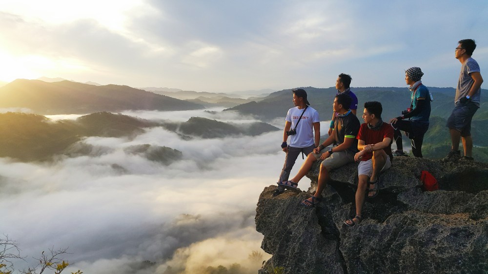
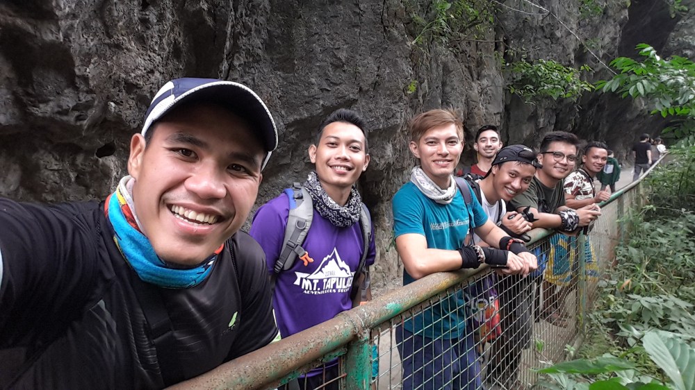
I invited some of my traveler friends [Joms (IG account: @whereisjoms), Juniel (@ph.juniel), Gerard (@radyorardo), Otep (@otepmercado) and JP (@jpeelosopo)] to join me in exploring Mt. Binicayan. As we opted to have a whole day of hiking, we included the nearby mountain of Pamitinan in our itinerary.
| MT. BINICAYAN | MT. PAMITINAN | |
| Location | Rodriguez, Rizal | Rodriguez, Rizal |
| Meters above sea level (MASL) | 424 MASL | 426 MASL |
| Specifics | Minor climb, 3/9 difficulty | Minor climb, 3/9 difficulty |
| Features | Limestone formations (Have you ever wondered why and how did limestones go up there in the mountains? J)
Scenic views of Sierra Madre, the longest mountain range in the country that is also home to other mountains such as Haponang Banoi, Ayaas and Sipit-Ulang |
|
We met up at 2 AM in Jollibee Farmer’s Plaza – Cubao (along EDSA). There was a nearby terminal where we rode a van going to Rodriguez, Rizal at around 2:30 AM. The ride from Cubao to Rizal only took us about 40 minutes as we have already arrived in Rodriguez at 3:15 AM. There we rode a tricycle going to the jump off point of Mt. Binicayan and Mt. Pamitinan. We arrived at around 3:20 AM, which was too early as the DENR office would be opening only at 4:30 AM. We decided to stay and rest first at a nearby eatery. Around 4:30 AM, we went back to the DENR office to register, pay for the environmental fee and secure a guide that would help us in our climb. There we met Kuya Joaquin, who’s probably one of the best guides that I’ve met so far. Not only is he reliable in guiding us on our journey to the mountains, he was also fun to be around as well as good in taking pictures! That’s why if you want to have an enjoyable climb to the mountains of Binicayan and Pamitinan, contact him at 09186464785.
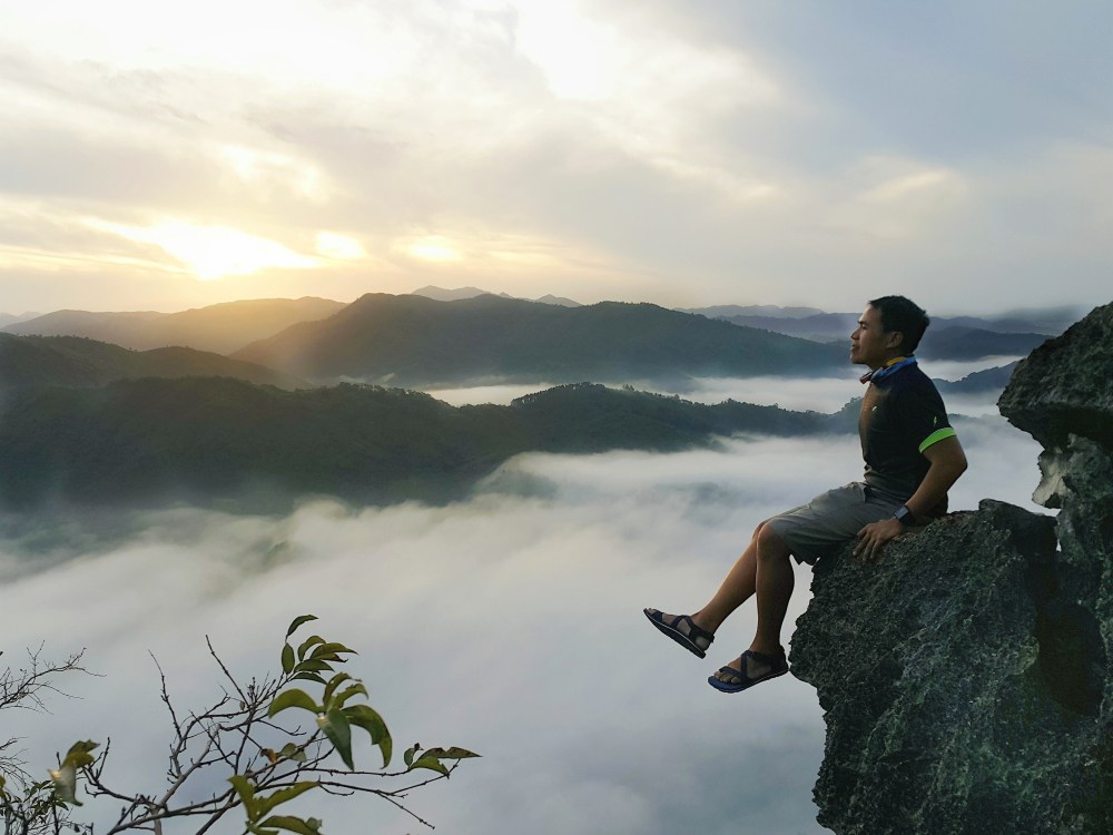
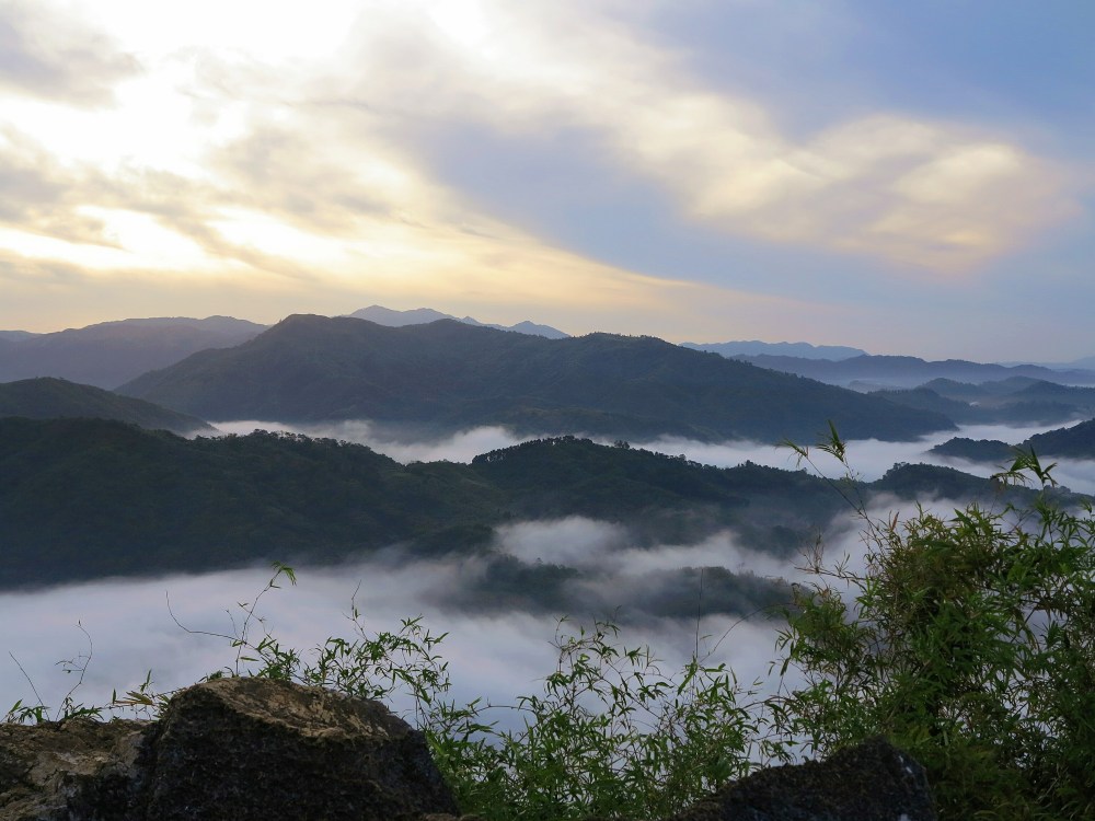
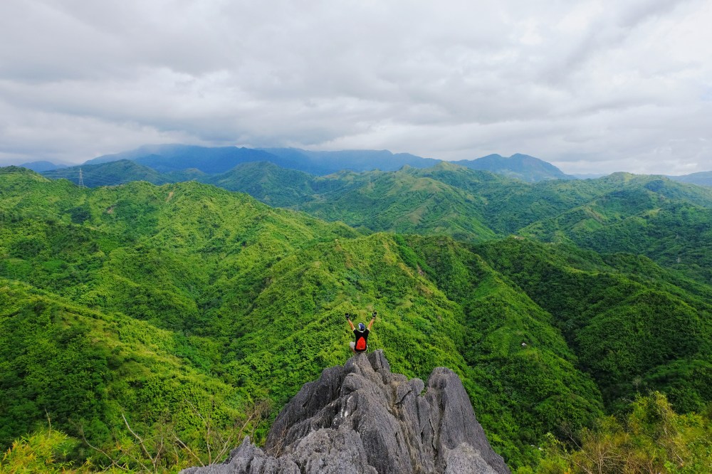
We were some of the first ones to be in the jump off point but many people have arrived since (and went straight to the DENR office) that’s why we were not the first ones to climb. Good thing that Kuya Joaquin knew a faster way of going to Mt Binicayan’s summit. Even though the trail required us to climb up boulders and some really high rocks, we were still able to go there just in time the dark sky was beginning to be illuminated by the sun. Lo and behold! What we saw after was the magnificent sea of clouds right before our eyes!
We marveled and took pictures of the beautiful scenery atop Mt. Binicayan. We took turns to have our solo shots in many different beautiful spots up there.
At around 8 AM, the sea of clouds was already receding that’s why we decided to descend the mountain. Upon reaching the jump off point, we took a rest and ate our breakfast. After about 30 minutes, we headed back to our journey and now to experience one of the most famous mountains for beginning hikers: Mt. Pamitinan.
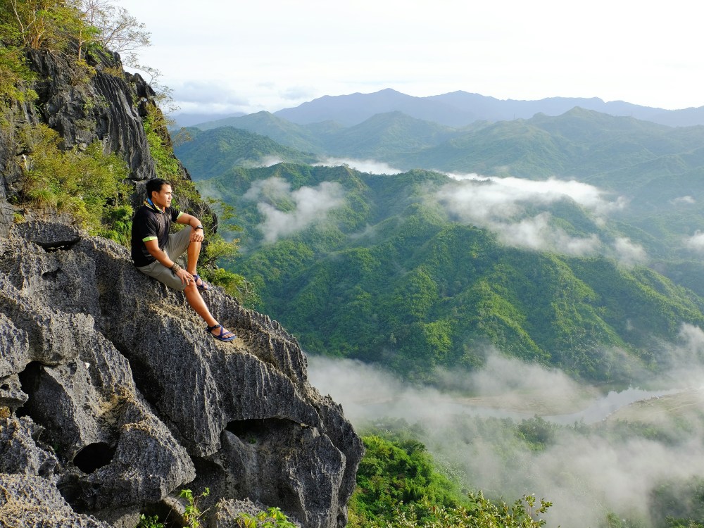
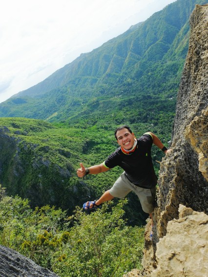
The trail towards Mt. Pamitinan’s summit wasn’t as hard or rocky as the trail towards the summit of Mt. Binicayan but there were still parts that would really require you to grip as hard as you can in order for you to climb. Meanwhile, there were many good spots for taking pictures here aside from the summit. Just be extra careful because these are cliffs, and one misstep could be a fatal mistake.
The trail wasn’t that long, however, it’s the number of people in Pamitinan that would make you spend a long time in it, especially because of their picture-taking in different scenic spots. (Climbers aiming for a trilogy are prioritized that’s why they are allowed to cut in line of those single mountain climbers or twin mountain hikers who are taking pictures in Pamitinan.)
We decided to do a traverse of Mt. Pamitinan so we did not go back to the way we did when going up the mountain. We wanted to visit Wawa Dam, which can be seen at the other side.
How much did I spend in this awesome adventure? Not that much, guys! Here is a breakdown of what I spent that day:
LIST OF EXPENSES
| ITEM | AMOUNT | REMARKS |
| Van from Cubao to Rizal | P50 | |
| Tricycle towards jump-off point | P20 | We were three in the tricycle and we paid P60 in all. |
| Registration/ environmental fee | P50 | |
| Guide fee- twin hike | P200 | The fee was P500 per mountain. We climbed two, that’s P1000. Our group of six decided to give P200 each (the remaining P200, as additional for our guide) |
| Food | P80 | You can bring your own food but there are stores along the trail serving food and drinks that can be bought at higher prices |
| River boat fare | P10 | If you don’t want yourself to get wet while crossing the Wawa River, you can ride a boat |
| Certification fee | P40 | A certification that you can present as one of the requirements before venturing into certain major climbs like Mt. Apo in Mindanao |
| Wash up fee | P25 | Shower beside the eatery near the DENR Office |
| Tricycle | P20 | Going back to the major road of Rodriguez, Rizal |
| Van from Rizal to Cubao | P50 | We got off in Philcoa to have our dinner but we still paid P50. Fare is the same regardless of where one will be getting off. |
| TOTAL EXPENSES: P545 | ||

Thanks, Idol! Very informative! I just realized we were taking down the same notes, this means i don’t have to write about this anymore and I can just refer friends to your blog post. Yey,less backlogs for me LOL! 😂😂😂
Hike again soon! 😄
LikeLiked by 1 person
Wow! Thanks, Joms! Alam mo naman tayo, we should be taking down these kinds of things. 😉 Hehe. Wow, sige, i-refer mo na lang sila rito sa blog. Thaaanks! And yes, hike again soon!!! 😀
LikeLike
Galing, Olivier!!! more more more!
LikeLike
Aww thanks, Lester!Yes, yes! 😀
LikeLike
Hi. I just want to ask kung DIY yung hike niyo? Any time pwedeng mag hike sa Mt. Binicayan? Ittext nalang ba namin si Kuya Joaquin?
LikeLike
Yup, DIY yung hike namin. Hindi naman anytime pwede. Hehe. Basta nagbubukas yung tourism office dun ng 4:30 AM. Medyo late na kung pupunta kayo ng 10 AM onwards lalo’t mainit na nun.
LikeLike
Advisable po bang umakyat this june? Kasi nag babalak po kami umakyat this june 13 sa mt pamitinan 🙂
LikeLiked by 1 person
Basta maganda ang panahon, walang problema. I-contact nyo yung guide nyo yung gabi bago ang akyat nyo para tanungin kung sakali. Good luck at enjoy!
LikeLike